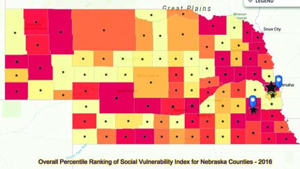
A Nebraska COVID-19 dashboard map, developed by DWFI Faculty Fellow Jesse Bell and colleagues, shows confirmed cases and deaths from the virus, along with vulnerable population data and health care resources. The map provides valuable insight to aid local decision makers.

The dashboard includes three separate tabs of information in a map overlay of Nebraska. The first tab shows the number of confirmed COVID-19 cases and deaths, hospital and nursing home contacts and capacities, pharmacies, and local health director contacts. The second tab shows social vulnerability data by county, which includes socioeconomic status; household composition in terms of disability, minority status and language; and housing and transportation information. The third tab includes population densities for persons 60 years old and older by 10-year increments.
Health department leaders and medical personnel across the state review the map daily for COVID-19 updates.
The map team is working to add data categories and additional states. Once the pandemic has subsided, the map could be updated and used for other types of disasters, as well.

