The institute is a trusted expert in technology and management practices related to high-productivity commercial agriculture. We innovate practices, technologies and decision support systems that can be applied and integrated into water-wise and climate-smart agricultural systems that are both productive and sustainable.
Water management for high-productivity commercial agriculture
Five-year DAWN project nears completion with more than 400 active users
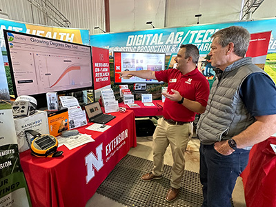
The DAWN (Dashboard for Agricultural Water Use and Nutrient Management) project is a free, web-based system designed to help U.S. Corn Belt row crop producers manage water and nutrient inputs more efficiently. Unlike traditional tools, DAWN uses advanced seasonal forecasts for six-month outlooks of temperature and precipitation, allowing farmers to compare past and predicted weather and customize insights. Developed through a USDA-funded collaboration led by the University of Maryland, the project involves several institutions including the University of Nebraska and DWFI, with DWFI Director of Research Christopher Neale leading work on evapotranspiration estimation and DWFI Faculty Fellow Guillermo Balboa leading outreach at the University of Nebraska–Lincoln.
DAWN offers various tools, such as the Crop Progress Tool for planting season planning, the Growing Degree Days Tool for predicting corn maturity, the Drydown Calculator for optimizing harvest timing, and the Irrigation Planning Tool for efficient irrigation schedules. Building trust with farmers has been crucial for DAWN's success, with direct engagement through field days and educational resources, leading to over 400 active users. As the five-year project nears completion, partners are assessing long-term sustainability strategies, and interest from the private sector is growing. Initially focused on corn, DAWN aims to improve profitability and sustainability by precisely managing inputs, reducing costs, and mitigating environmental impacts through science-based tools and farmer-centered design.
Flux tower network expands to Upper Colorado River Basin states
DWFI continues to expand the Parallel 41 Flux Tower Network of water and carbon-equivalent flux towers and analytical tools through grants and subawards. This year, through a five-year, $3.4 million initiative funded by the Upper Colorado River Basin Commission, DWFI installed 10 new eddy covariance flux towers across Wyoming, Colorado, and New Mexico to enhance understanding of the interactions between croplands, water resources, and the atmosphere to improve irrigation consumptive use estimations and water management. The tenth tower was installed in the spring of 2025 in Farson, Wyoming. The data provided by all the towers will be used to verify satellite remote sensing-based estimates of evapotranspiration, including DWFI’s GLODET daily evapotranspiration product.
The flux tower network is part of DWFI’s suite of water management tools that accurately determines a crop’s unique daily water needs. This precise data assists in assessing irrigation water consumption, water budgets, water productivity, plant stress, and drought – ultimately helping growers apply the precise amount of water that crops need, when they need it, to achieve the best possible yields and minimize losses. The capabilities of this suite of tools has attracted numerous partnerships, grants and interest since the work began and the tools can now also help validate carbon credits, and provide the science to support the negotiation of inter-state agreements, including on the Platte River in Nebraska.
Optimizing irrigation through next-generation crop models
DWFI, in collaboration with USDA Agricultural Research Service (USDS-ARS), is spearheading advancements in crop modeling to revolutionize agricultural decision-making. This vital project, led by Nebraska Water Center researchers, focuses on refining existing simulation models for key crops like corn, soybean, cotton, rice, and potato. By enhancing these models, DWFI empowers producers with unprecedentedly accurate data on daily water needs, optimizing irrigation for maximum yields. The enhanced models also incorporate critical climate change factors like atmospheric CO2 and temperature shifts, offering a crucial tool for adapting to a changing climate.
A significant stride in this initiative was a crop simulation model workshop at the 2025 Water for Food Global Conference. This workshop, led by USDA-ARS Adaptive Cropping Systems Laboratory (ACSL) scientists, introduced participants to CLASSIM, a user-friendly graphical interface that simplifies the use of USDA crop models. Attendees gained hands-on experience simulating diverse agricultural scenarios, deepening their understanding of plant growth, development, and yield responses under various management and environmental conditions. This project not only refines the science behind crop management but also crucially bridges the gap between complex research and practical on-farm application, solidifying DWFI's commitment to a more resilient and productive agricultural future.
Evaluating the economic impact of groundwater regulation through a case study of Nebraska
DWFI and UNL researchers published a blog sharing key findings from ongoing research evaluating the economic implications of agricultural groundwater regulations in Nebraska. The investigation analyzes the effects of policies such as well moratoria and groundwater allocation quotas on farmland values. Fluctuations in land prices serve as a critical indicator of potential economic impacts on rural communities. A decline in these values often suggests an anticipation of reduced future profitability and potential economic contraction. There is increasing emphasis on groundwater management throughout the American West and growing concerns regarding long-term water resource availability. Nebraska's distinct history of implementing varied groundwater management policies provides a valuable opportunity to investigate the economic consequences of these regulations, yielding crucial insights for the broader discourse on water resource stewardship.
Advancements to Global Daily Evapotranspiration project expand its use to new areas
The Global Daily Evapotranspiration (GLODET) project is advancing its capabilities to run the model over new regions of the world independently of NASA partners. GLODET is a free portal to view and download global daily evapotranspiration (ET) spatial datasets. ET represents daily crop water use and is a useful metric for water accounting, water productivity analysis, irrigation scheduling, variable rate irrigation and drought monitoring.
Other enhancements to GLODET include implementing PyDisALEXI (an open-source model designed for estimating ET at field scales using Landsat data) to examine water demand at the field level, improving the spatial resolution from 370 meters to 30 meters. With DWFI student support, Ph.D. students are also using GLODET to study the hydrology of the river basins feeding the Panama Canal and the Upper Colorado River System. Planning is underway to further expand the use of GLODET to the Nile River Basin.
A foundational understanding of commonly irrigated U.S. crops and irrigation methods
DWFI and the National Drought Mitigation Center have published two resources that explain how major US irrigated crops—from water-intensive rice to corn and soybeans irrigated with mobile sprinkler systems—require specific water solutions. These resources, "Common Irrigation Methods in the US" and "Commonly Irrigated Crops in the US," provide a foundation to understand the links between agricultural practices and water stewardship. This work complements DWFI past work on agricultural water use in the U.S.