As an academic who often engages with public and private stakeholders, I see firsthand how important it is to connect classroom learning with experiences applicable to the “real world.” This often includes tailoring or advancing specific technical and professional development skills required by current or prospective employers. I’ve been focusing on helping to make more such experiential learning opportunities available to the Daugherty Water for Food Global Institute’s (DWFI) and the University of Nebraska’s key audiences, including students, staff, faculty, and the broader Nebraska and global community. To that end, over the past year, I’ve learned a lot about various opportunities that can be made available through micro-credential courses. In fact, I’ve teamed up with university experts to design and test a few such courses.
Below, I share my summary about the micro-credential courses, including opportunities through DWFI and key insights from my colleague Taro Mieno, who has recently taught a micro-course, “Spatial Data Handling and Map Creation Using R.”
What are micro-credential courses?
Micro-credential courses (often called “micro-credit courses” or “micro-courses”) are zero-credit experiential skill-building opportunities. Though highly flexible in their designs, micro-credential courses are typically short-term workshops created to provide competencies in marketable technical and professional development skills. A popular way to recognize the gained competencies through such courses is by awarding top performers with a digital badge, which learners can easily share on their resumes and professional social media accounts.
Why are micro-credential courses useful?
The flexibility associated with the design of micro-credential courses offers many benefits to learners, potential employers, and instructors developing the courses, leading to an overall greater educational impact. Such benefits include (i) increasing learners’ marketability to better meet potential employers’ needs; (ii) advancing learners’ performance in classes and other professional settings; (iii) allowing instructors to reach broader audiences - learners within and outside the University of Nebraska system; (iv) increasing stakeholder engagement and visibility.
Micro-credential initiatives by the Daugherty Water for Food Global Institute
In the summer of 2024, DWFI implemented a couple of micro-credential pilots. The process involved teaming up with experts at the University of Nebraska to create opportunities that are meaningful and relevant to making an impact in the water and agriculture space.
One of those pilots is the “Micropipette Mastery” micro-credential course taught by experts at the Water Sciences Laboratory at UNL. Micropipettes are used daily in almost all professional laboratory environments for liquid handling and require practice to repeatedly perform accurate and precise sample dilutions and additions of standard mixtures. The micro-course focuses on training learners to use a micropipette correctly, consistently, and accurately. This provides an opportunity for learners to acquire a key skill that is not offered in a classroom setting but is needed to work in an environmental laboratory. Learners can gain competency in this technical skill by attending in-lab training and passing a micropipette proficiency test. The micro-course is self-paced and ongoing.
Another pilot, which is now completed, was designed with DWFI’s faculty fellow, Taro Mieno, who is an associate professor at the Department of Agricultural Economics at UNL. Taro taught a micro-course on data handling and visualization in R using publicly available data on agriculture and water. The eight-session-long workshop focused on utilizing spatial datasets in R, which included creating informative maps for effective communication with audiences interested in water and agriculture-related issues.
Insights from offering the “Data Visualization in R” micro-credential course
I spoke with Taro about his experience teaching the micro-course.
Renata: Taro, why did you want to teach a micro-credential course on using R for data visualization?
Taro: As a faculty member at the Department of Agricultural Economics, I teach a class called “Data Science for Environmental, Agricultural, and Social Scientists” every fall. While using R as a tool to handle spatial datasets and create maps is a component of this class, I have long wanted to teach this specific aspect in a more focused, shorter format, especially given its growing significance. For this purpose, testing a micro-credential tool was a perfect avenue.
The importance of spatial data handling has noticeably grown across various scientific fields. In addition, high-resolution spatial datasets that capture detailed information over time and space are becoming more publicly available. Some examples of such datasets include OpenET, gridMET, and the U.S. Census.
From my previous experience collaborating with the DWFI on water economics research, I knew that data visualization to communicate findings is important in their work. So, working together to design and implement this opportunity made great sense.
Renata: What was the structure of your micro-course?
Taro: The micro-course was designed as a hybrid format workshop. It consisted of eight two-hour long sessions spanning over four weeks during the summer. Students were required to attend the sessions and complete assignments, including a small project demonstrating data visualization in R competency. Those who met the requirements were recognized with digital badges.
The course was offered at no cost for attendees. It was open to students, staff, and faculty affiliated with any of the University of Nebraska campuses, as well as individuals outside the university. Because this was the first time I offered the micro-credit course, I limited enrollment to just ten students, and the spots filled quickly. Despite the small class size, the participants had a variety of backgrounds and interests in various scientific fields, including agricultural economics, natural resources, and agronomy, where spatial data management is often critical.
Renata: Can you share more about the content of your micro-course?
Taro: The course covered an extensive range of spatial data management and wrangling techniques, including the fundamentals of vector and raster data, spatial interactions, creating informative maps, and acquiring spatial data directly in R. It was a condensed version of the free online book I published, titled “R as GIS for economists.”
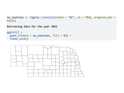
Learning these skills through R, as opposed to using graphical interfaces, can be challenging, especially for those unfamiliar with programming. To address this, the course emphasized reproducibility and repeatability, aiming to build the learners’ confidence in using R for spatial analysis. Although spatial operations in R can be complex, they are ultimately rewarding due to the flexibility R offers. The code below may give you a good sense of how R can be powerful, where a few lines of code create a reproducible map of Nebraska counties.

Renata: Will you teach the same micro-course again?
Taro: Yes, I would like to. Teaching the micro-course was highly rewarding. I felt that I was making a difference in the participants’ scientific endeavors, and I received positive feedback. Also, offering the micro-course was not as demanding as a regular class as it was much shorter. Following the learners’ suggestions, however, I would slightly modify the micro-course next time around by offering more exercises to enhance their understanding of the course materials.
What opportunities would you like to see offered?
It is exciting to hear about positive outcomes from micro-credential opportunities. To build on the gained momentum, we at DWFI continue working with partners to create more technical and professional development skill training opportunities using the micro-credential tool.
Do you have ideas about experiential learning opportunities? I’d love to hear from you. Email me at rrimsaite@nebraska.edu (Renata Rimšaitė).


