

By: Carrillo, R1., Rimšaitė, R1., Knutson, C2., Cobbing, J.1
1Daugherty Water for Food Global Institute at the University of Nebraska
2National Drought Mitigation Center, University of Nebraska–Lincoln
Executive summary
Water demand is increasing across the United States and precipitation patterns are becoming more variable, affecting agricultural production. These challenges place a growing pressure on water resources management nationwide, especially in eastern U.S. regions that have historically received reliable precipitation. Georgia is one of the states experiencing these challenges. In recent decades, Georgia has experienced severe drought, interstate water law litigation and a growing demand for agricultural water use. To address these challenges, the state has implemented several innovative water conservation strategies, including multiple irrigation suspension auctions in an agriculturally rich and environmentally important region. This report examines the state of Georgia's water resources and its challenges, with a focus on agricultural water use, to better understand current policy approaches and water governance strategies for water management. It is intended to provide an overview for other regions facing similar conditions to learn about ongoing or tested efforts in agricultural water governance.
Highlights
- The state of Georgia is one of the many U.S. states facing increasing weather variability and drought. Recurring drought, rising temperatures and changes in precipitation patterns affect water availability on the surface and in the state’s aquifers. Inconsistent water availability puts a strain on shared water resources. Agricultural producers, in addition to municipalities, industry and ecosystems, are likely to experience increased competition and uncertainty in securing sufficient water.
- Georgia’s agricultural production relies heavily on irrigation. The combination of the state’s natural hydrology with increasing weather variability has created an agricultural industry reliant on irrigation, especially in the southwestern and eastern regions. Producers in Georgia typically irrigate peanuts, cotton and corn on a three-year rotation. While agricultural production has increased with the use of irrigation, pressure on water resources has also increased.
- The state of Georgia faces several water governance challenges that may limit the implementation of effective and scalable water management approaches. Administrative constraints and aspects of the state’s water law can make it difficult to expand incentive-based water management programs and adapt to changing water demands. To address water conservation challenges, Georgia has implemented a variety of water policies and management strategies, including statewide and regional water planning; groundwater withdrawal permitting and restrictions; and voluntary irrigation suspension auctions. Looking ahead, future water management efforts may increasingly rely on water conservation incentives, voluntary programs and regulatory restrictions.
Introduction
Water is a vital resource for Georgia’s environment, economic development and agricultural production. The state has a variety of water resources to draw upon, including numerous surface water systems, rich groundwater aquifers and individual regional weather patterns. These water resources support Georgia’s large municipalities, such as the Atlanta metro; industries; forest and aquatic ecosystems; and the agricultural sector. The state’s agricultural production relies on consistent water availability for stable crop yields. Historically, the availability of groundwater and surface water resources was sufficient to meet agricultural demand. However, various factors have contributed to Georgia’s water resources conservation challenges. These include growing water demand for agriculture and other uses due to increasing weather variability and population growth, as well as interstate water disputes. These changes impose significant challenges for water users and the management of the state’s finite water resources, particularly during drought periods.
Therefore, the purpose of this report is threefold:
- to examine the status of Georgia’s water resources and identify challenges to water users, with a specific focus on agricultural water users;
- to better understand how the state’s water resources are managed and identify existing and potential market-based approaches to irrigation management; and
- to inform other regions experiencing similar conditions about water governance approaches that have been tested in Georgia.
The first section of the report provides an overview of Georgia’s hydrology and agriculture, including surface water and groundwater interactions; changes in weather patterns; the development of agriculture; and irrigation practices in the state.
The second section provides an overview of Georgia’s foundational water law, water policy and drought and hazard mitigation plans. This section reviews the state’s riparian and reasonable use doctrines; water withdrawals and permitting systems; regional water planning efforts; and drought and hazard mitigation policies.
The third section reviews Georgia’s existing and potential market-based approaches to irrigation management. It reviews emerging market-based approaches in Eastern U.S states and evaluates Georgia’s past irrigation suspension auctions in southwest Georgia.
Hydrology
Groundwater
The state of Georgia is divided hydrologically by the “fall line,” a geographic boundary separating the sediments of the coastal plain from the largely crystalline rock and limestone aquifers of the northern and northwestern part of the state (USGS & Georgia EDP, 2025). The coastal plain consists of thick layers of sand, clays, dolomites and limestones that dip and thicken to the southeast (Clarke & Pierce, 1985). Groundwater in the sand aquifers occurs mainly in the pore spaces, the space between grains of sediment. Most large groundwater abstractions in Georgia are from the coastal plain aquifers in the south, with the most productive aquifer in this sequence being the Floridan Aquifer System. Wells in the Floridan Aquifer can yield between 1,000 to 5,000 gallons per minute. The coastal plain aquifers are major water sources in the state for municipal, industrial and agricultural purposes. Average annual groundwater recharge across the state is about 12% of rainfall. The total area of Georgia is about 59,425 square miles, implying a total groundwater recharge volume of about 5.7 cubic miles (USGS & Georgia EDP, 2025 & Clarke & Pierce, 1985).
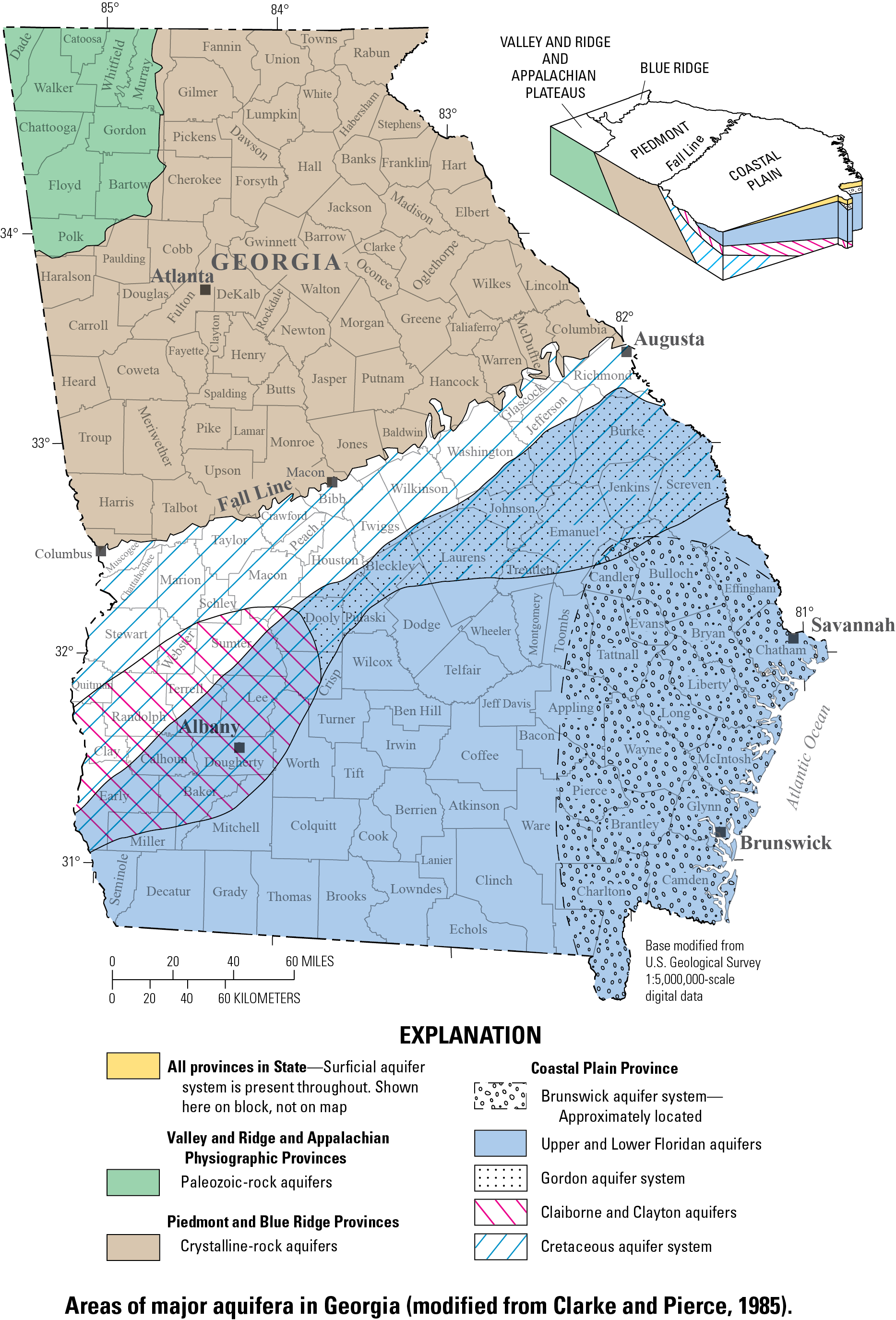
Figure 1. Georgia hydrology map.
Source: Reprinted from USGS & Georgia EPD, 2025.
Above the fall line, as seen in Figure 1, aquifers are developed in faulted sedimentary rocks and in metamorphic and igneous rocks of the Piedmont and Blue Ridge Provinces; the Valley and Ridge Provinces; and the Appalachian Plateau. Groundwater in these rocks is found mainly in joints, cracks, fractures and other secondary openings. Clarke and Pierce (1985) state that these aquifers are substantially less productive than those of the coastal plain, particularly where the rocks are massive and secondary porosity is low. For example, in the crystalline rock aquifer provinces, yields are commonly around 1-25 gallons per minute and in rare cases may exceed 500 gallons per minute.
Groundwater quality in Georgia varies by aquifer depending on the environmental or human factors affecting each. Throughout the state, shallow groundwater resources are associated with saprolite, alluvium and other surface and drift deposits (NGWA, 1986). Bedrock thickness and sediments may influence groundwater quality depending on the region in Georgia. Seawater intrusion caused by over-pumping can impact groundwater quality in the coastal plain aquifers (Chumbley & Scroggs, 2024). Anthropogenic pollution, particularly agricultural operations, may also impact groundwater quality (Willis, et al., 2025).
Surface water
The state of Georgia contains an extensive and diverse hydrologic network that encompasses rivers, streams, wetlands, lakes and a coast. Georgia freshwater resources include over 44,000 miles of perennial streams and nearly 24,000 miles of intermittent streams (Georgia Rivers, 2025). The state’s river system is extensive, with 14 major river basins that are organized into 52 individual watersheds, as defined by the state. Most of these rivers begin in northern Georgia and increase in size as they travel south through the state (USGS, 2008). Georgia’s surface water systems are critical for its agriculture, municipal and industrial water supply, in addition to supporting aquatic ecosystems, recreation and regional biodiversity. As of 2020, surface water accounts for 21% of the total agricultural water demand, making it a vital resource (Georgia, Water Planning, 2025). The northern portion of the state relies on surface water as a primary water source, while the rest of the state uses a combination of surface water and groundwater sources. These surface water sources also support approximately 4.8 million acres of wetlands; over 425,000 acres of public lakes and reservoirs; and more than 850 square miles of estuarine environments (Georgia Rivers, 2025). The availability of surface water in Georgia is influenced by seasonal precipitation, drought and competing demands among agricultural, municipal, industrial and ecological users. Surface water management is thus an important part of Georgia’s long-term water planning efforts.
Weather
Georgia experiences a variety of weather conditions within its six main ecological regions: the Southwestern Appalachians; Ridge and Valley, and Blue Ridge in the north; the Piedmont and Southeastern Plains in the central part of the state; and the Southern Coastal Plain in the east (SAWSC, 2023). Annual average temperatures vary from 46.1°F to 79.7°F and depend on the region. The climate is described as humid subtropical (Knox & Mogil, 2020). Extremely high temperatures do not occur regularly. However, from 2016 to 2019, Georgia experienced its hottest years recorded and set temperature records of up to 109°F (NCEI, 2022).
In addition to temperature changes, precipitation patterns across Georgia also vary by region. Rainfall in Georgia averages around 50 inches per year, with the driest counties in the southern coastal plain and the wettest in the northern part of the state (Wickham, 2026). Northern Georgia receives rain evenly throughout the year, while southern and coastal Georgia regions receive rain predominantly in the summer (Britannica, 2026). The state has a shoreline along the Atlantic Ocean and is also located near the Gulf of Mexico. Proximity to two large bodies of water makes the state vulnerable to tropical systems and large storms (Knox & Mogil, 2020).
Increasing weather variability poses a series of social, economic and environmental challenges to the state of Georgia (TNC, 2025). Georgia has already faced rising sea levels; retreating shoreline; more frequent tropical storms and hurricanes; increased air pollution in cities; and inland flooding and droughts. Georgia's worst drought in recorded history occurred from 1924 to 1927 and prompted rural communities to move to larger municipalities, such as Atlanta. Other severe droughts have occurred from 1998 to 2002; 2007 to 2009; 2011 to 2013; in 2016; and in 2019 (Knox & Mogil, 2020). Recent rapid-onset droughts, although short in duration, have threatened the quality and quantity of Georgia’s water resources. This puts the stability of the state’s agricultural production–particularly in the productive, drier regions of southwestern and southeastern Georgia–at risk.
Agriculture
Major crops
Before the 1700s, agriculture in Georgia primarily consisted of locally planted beans, squash and corn (Worth, 2001). By the early 1700s, new crops in Georgia were established, including non-native fruits, cotton, tea and Mulberry trees for silk production. Later, rice became a major agricultural product, particularly along Georgia's coastal areas. Indigo, cotton and corn were also produced on a large scale. While sugar cane and rice were planted along Georgia’s coast, cotton fields expanded throughout the rest of the state in the 1800s. Later, the Civil War greatly reduced Georgia’s agricultural production and the previous agricultural system transformed into a sharecropping system. By the early 1900s, livestock production grew and producers experimented with growing new fruits and vegetables (Messick et al., 2001).
In the present day, agriculture is a significant driver of Georgia’s economy, contributing $91 billion annually and over 300,000 jobs (Farm Bureau, 2024). Georgia has over 9.9 million acres of cropland with an average of 261 acres of cropland per farm operation (USDA, 2025). Twenty-seven percent of the state’s land is used as farmland. Georgia’s leading crops include peanuts, cotton, corn, hay, melons and soybeans (Prillaman, 2021). The state is also a major producer of broiler chickens and eggs (producing over a billion head in 2025), as well as a significant contributor to the timber industry (USDA, 2025).
Irrigation
Throughout Georgia’s agricultural history, the state relied on natural rainfall to water cropland. Many fields were also lined with irrigation canals (Messick et al., 2001). Modern-day irrigation in Georgia has developed only in the past 50 years (Georgia Water Coalition, 2017). A major drought in the 1950s prompted federal investment in developing irrigation in the southern U.S. states. One such investment included the Watershed Protection and Flood Prevention Act of 1954, which provided financial assistance to entities planning and installing watershed projects, including irrigation. In the 1960s through the 1980s, both drought and new strides in irrigation and chemigation techniques caused irrigation in Georgia to rapidly grow (Pierce et al., 1984). These programs, along with improved irrigation technologies, resulted in the expansion of irrigation across the state (Georgia Water Coalition, 2017).
Georgia farmers use a variety of irrigation technology systems, including center pivots, micro sprinklers and drip irrigation, with center pivots covering the largest amount of irrigated acreage in the state (Yu et al., 2011). Currently, 50% of Georgia's total cropland is irrigated and the state is predicted to see an increase in irrigation demand across all areas of the state in the next 50 years (Georgia Water Coalition, 2017). The Flint River Basin, in southwest Georgia, uses the most water to irrigate crops out of all other regions in the state. Peanuts, corn and cotton make up a common crop rotation in the Flint River Basin, with each crop rotating once per growing season. In the eastern Coastal and Savannah-Upper Ogeechee regions, irrigation use is increasing the fastest (Georgia Water Coalition, 2017). From row crops to a variety of vegetables and fruits, irrigated crops in Georgia have an extensive range. The most irrigation-intensive crops include corn, cotton, peanuts and soybeans (Porter, 2021).
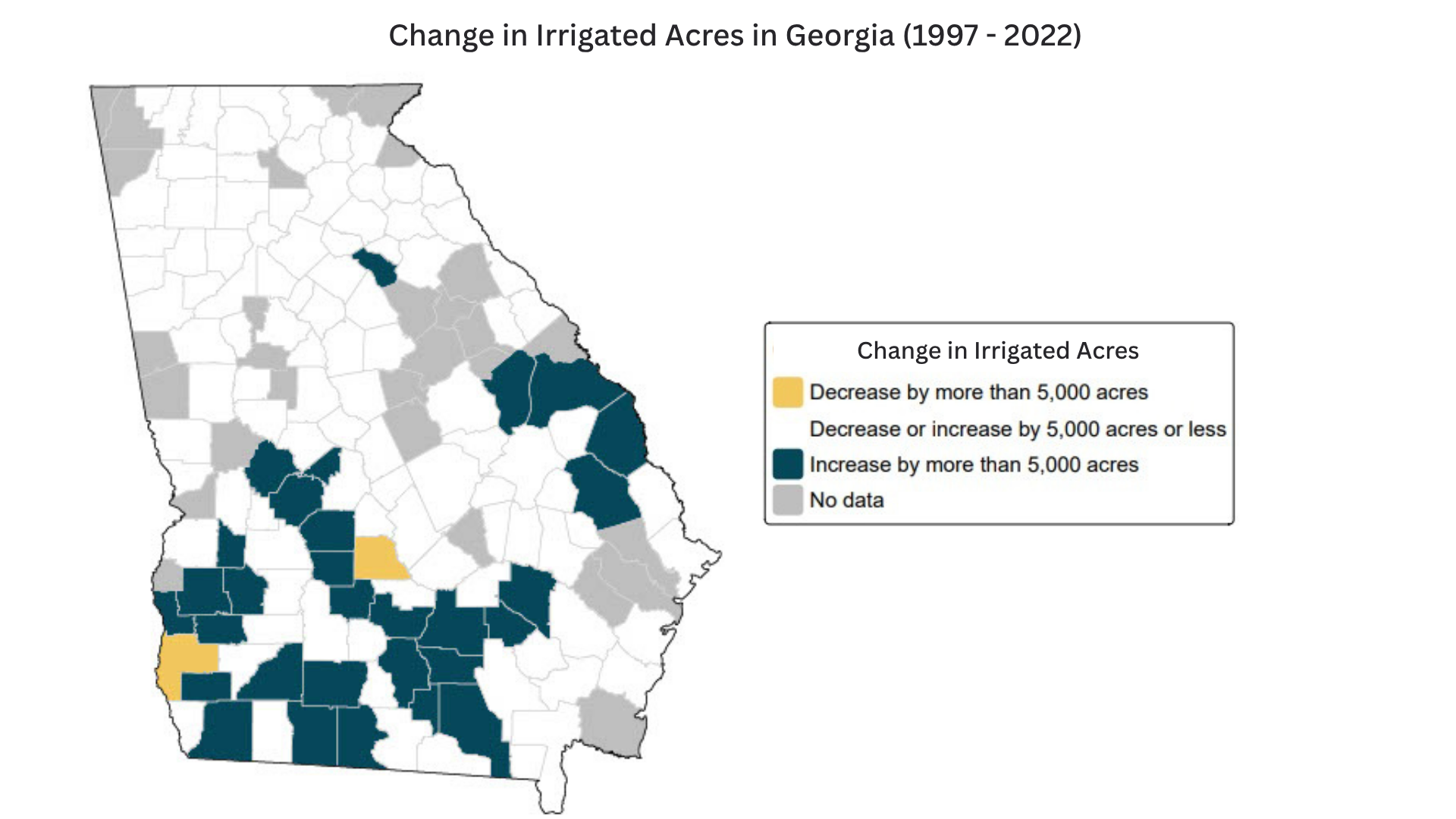
Figure 2. Change in Georgia’s irrigated acres from 1997 to 2022.
Source: USDA Irrigation and Water Management Survey, 2022; 2026
Overall, water use for agriculture in Georgia has increased. In 2003, statewide irrigation land totaled 710,893 acres. As of 2023, the amount of total irrigated land has risen to 1,222,368 acres (USGS, 2003; USGS, 2023). Between 1997 and 2022, parts of eastern and southwestern Georgia expanded irrigation by more than 5,000 acres at the county level (see Figure 2), which includes counties such as Mitchell, Colquitt, Crisp and Dooly. Aquifers in these regions are productive and can support groundwater withdrawals for agriculture (USGS, 2025). Irrigation allows producers to grow a larger variety of crops. However, the growing demand for irrigation places pressure on groundwater resources and increases the likelihood of future challenges when drought or extreme weather may occur. State programs have been implemented to conserve water for agriculture and are discussed in the section on state water governance below.
State water governance
Water law
Georgia’s groundwater and surface water resources are considered a public resource, belonging to the state and managed as a public trust. The governance of these resources is based on the riparian and reasonable use doctrines. Under these legal systems, landowners are generally allowed to legally use water that touches their land, provided the use is for a beneficial purpose and not wasteful (Williss et al., 2025). These legal systems were originally developed for contexts with abundant water resources, such as the eastern U.S. and including the state of Georgia. However, determining what constitutes a reasonable use can become more complex during periods of water scarcity, which are becoming increasingly common among Georgia’s various water users. Although Georgia’s water management law is a regulated riparian system overlaid with regulation of withdrawals and wastewater discharges, managing competing water uses during periods of scarcity may present increasing challenges. For example, legal conflicts may arise when one user believes their domestic water well has run dry due to increased agricultural water use nearby. Disputes among users may increase as water use intensifies, driven by continued weather variability and growing water demands for agriculture, domestic use, environmental needs and industry.
Georgia has also faced many decades of challenges to its water law. An interstate water law conflict (often referred to as the “Tri-State Water Wars”) has been ongoing between Alabama and Florida since the 1990s. Georgia, Alabama and Florida share water systems that cross state borders. These water systems, including the Alabama-Coosa-Tallapoosa (ACT) and the Apalachicola-Chattahoochee-Flint (ACF), are geographically and hydrologically complex. Thus, the states have undergone numerous lawsuits to determine who has access to water and how much water can be used. Lawsuits reached the U.S. Supreme Court several times, including litigation between Florida and Georgia over fair apportionment of the ACF. In 2021, the Supreme Court dismissed Florida’s original case due to lack of evidence that Georgia’s water consumption caused injuries. The latest round of litigation from Alabama was dismissed and currently, there are no active litigations between the states (SELC, 2025). Outside of litigation, efforts to form a compact among the states have failed. The impact of interstate water conflicts on Georgia includes water withdrawal permitting restrictions; moratoriums in the ACF; water conservation efforts in the Atlanta metro; and upgrades to wastewater management practices.
Water policy
Georgia adopted a statewide water plan in 2008 after the passing of the Comprehensive State-Wide Water Management Planning Act in 2004. The State Water Plan provides a broad structure for water resource management in the state, including the establishment of 10 regional water councils. In the plan, agricultural water users are treated the same as other water users. Georgia operates a forecasting dashboard with water demand forecasts to maintain the State Water Plan. The State Water Plan is also informed by continuous groundwater monitoring through coordinated efforts between local governments, private industry and state and federal agencies (e.g., the Georgia Department of Natural Resources Environmental Protection Division; the Molson Coors Beverage Company; and the National Ground-Water Monitoring Network (USGS, 2025).
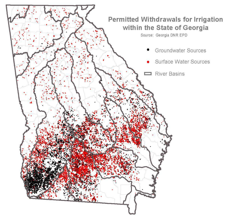
Figure 3. Permitted withdrawals for irrigation within the state of Georgia in 2010.
Source: Reprinted from Georgia DNR EPD, 2010.
Surface water and groundwater use is regulated through permits enabled by the Georgia Groundwater Use Act and the Georgia Water Quality Control Act. The Army Corps of Engineers oversees major reservoirs in Georgia, including Lake Lanier and Lake Allatoona, both of which are major sources of municipal water (ACOE, 2026). The Georgia Environmental Protection Division (EPD) oversees the Watershed Protection Branch, a state government branch that administers water permitting programs for multiple uses, including agriculture (Georgia EPD, 2025b). Groundwater withdrawal permits, most common in the southwest region of the state (see Figure 3), are for water withdrawals of 100,000 gallons or more. These permits, often issued for agricultural water use, are granted for up to 25 years, with the possibility of a longer permit as approved by the EPD Director (Georgia EPD, 2025a).
There is a specific distinction between permit applications for groundwater use within the Flint River Basin. The Flint River Basin is part of the larger ACF River Basin, located in the southwestern part of the state. Georgia’s involvement in interstate legal disputes over water use–combined with severe drought conditions; imperiled aquatic fauna in the region; and interactions between groundwater and surface water–contributed to the Georgia EPD’s decision to suspend new and expanded water withdrawals in the Lower Flint River Basin (Georgia EPD, 2025a). The suspension was originally put in place in 2012 and not relaxed until 2025. Since 2006, permit applications within the Flint River Basin carry a $250 fee and automatically renew for another term unless an evaluation indicates that the water use is causing an unreasonable adverse effect on other water users (GA Code § 12-5-105). Permit applications across the rest of the state do not require a fee (Georgia EPD, 2025a).
The Georgia Soil and Water Conservation Commission (GSWCC) oversees soil and water resources by incentivizing the adoption of best management practices (GSWCC, 2025). Funded by the federal Farm Bill, the GSWCC’s best management practices aim to improve agricultural planning and irrigation water planning. The most recent management practices, issued in 2013, provide water conservation and irrigation efficiency strategies for producers. While participation in the program is voluntary, the GSWCC offers cost-share programs and other financial incentives for producers to implement these practices. The GSWCC also oversees Georgia’s 40 Soil and Water Conservation Districts. These districts seek to inform the state of the regional needs and concerns related to soil and water conservation. The districts also conduct state programming to connect farmers and promote conservation practices (GSWCC, 2025).
To address regional water needs, the Georgia State Water Plan mandated the creation of regional water plans and regional water planning councils (GSWCC, 2025). There are 10 Regional Water Plans and councils, including: Altamaha, Coastal Georgia, Coosa-North Georgia, Lower Flint – Ochlocknee, Metro Water District, Middle Chattahoochee, Middle Ocmulgee, Savannah-Upper Ogeechee. Suwannee-Satilla, Upper Flint and Upper Oconee. Each Regional Water Council has its own goals, water plan and implementation methods. Some regional water plans include recommendations for producers that are similar to GSWCC’s best management practices. Recommendations vary from practicing conservation tillage and installing end-gun shutoffs on center pivots to identifying incentive-based cost-share programs to conserve water (GSWCC, 2025).
Georgia also receives support from various federal programs. The Natural Resources Conservation Service (NRCS) works directly with the Soil and Water Conservation Districts to identify conservation concerns and create solutions (NRCS, 2026). The NRCS primarily conducts the Environmental Quality Incentives Program (EQIP). EQIP provides technical and financial assistance to Georgia producers to address natural resource concerns. In addition to the NRCS, Georgia receives support from the Conservation Reserve Enhancement Program (CREP). This program, overseen by the Farm Service Agency, is a voluntary program that provides cost-share assistance to producers who convert farmland deemed environmentally sensitive into vegetative cover (NRCS, 2026).
Drought and Hazard Mitigation Plans
In 2015, Georgia established its official Drought Management Rules, replacing the state’s outdated drought plan. The Drought Management Rules, adopted to address municipal water use during drought, outline pre-drought mitigation strategies and identify drought indicators and triggers for activating drought responses. Agriculture is exempt from these provisions (Georgia EPD, 2026a). Georgia also addresses climate-related hazards through its State Hazard Mitigation Plan (GAEMHSA, 2024). The Hazard Mitigation Plan, last updated in 2024, includes a risk assessment for the entire state. Hazard mitigation strategies and mechanisms for coordinating local mitigation assistance are outlined in the plan. Drought is listed as a high-priority-level natural hazard and the financial impact of crop losses are evaluated in the plan. Consistent with federal requirements, all Georgia counties are expected to maintain their own local hazard mitigation plans. These local plans are then reviewed and approved by the Federal Emergency Management Agency (FEMA) every five years. Together, the state’s Drought Management Rules, State Hazard Mitigation Plan and local hazard mitigation plans aim to help the state address future drought challenges (Georgia Emergency Management, 2025).
Market-based approaches to irrigation management
Water markets
Agricultural water markets are a type of voluntary, incentive-based water management tool that can increase flexibility and reduce production risk associated with water scarcity. Well-functioning water markets reallocate water from lower to higher valued uses without compromising access for other water users, including domestic and environmental uses (Young & Brozović, 2019; Rimšaitė & Brozović, 2023). Water market mechanisms operate in many regions across the U.S. and globally, varying in structure, formality and legal oversight. In the U.S., water markets are primarily concentrated in the western and southwestern regions, which have long experienced semi-arid conditions and water shortages. The development of water markets in these regions is closely linked to the prior appropriation doctrine, which serves as the legal foundation for most western water rights systems. Unlike riparian and reasonable use systems used in eastern states, prior appropriation allows water rights to be separated from land ownership and transferred to other users (Willis et al., 2025).
Water market mechanisms are less common in the eastern U.S., mostly because the region has historically received sufficient rainfall and experienced much less water scarcity. As a result, water law (i.e., the riparian and reasonable use doctrines) was not designed to address water shortages in the same way as prior appropriation, including the accommodation of formal water transfers. However, some states have implemented different market-based mechanisms. Examples include Georgia’s irrigation suspension auctions (see section on irrigation suspension auctions below), Florida's Dispersed Management Program (Sumner, 2015) and Delaware River Basin's Water Charging Program (DRBC, 2026).
Formal agricultural water markets could provide greater flexibility for Georgia farmers, particularly in the southwestern region, where water risk and sustainability concerns have become more severe. Growing agricultural water demand and the varying water requirements of diverse crops demonstrate that water could be transferred to higher-valued uses, creating economic benefits for water market participants (i.e., water rights buyers and sellers). However, beyond water risk, economic need and variability in water values, the conditions for successful formal water markets also include strong legal and administrative frameworks (Young and Brozović, 2021; Rimšaitė and Brozović, 2023). Establishing such a market in Georgia would require adapting the state’s existing legal framework. This type of change was unsuccessfully considered by the Georgia General Assembly with House Bill 237 (HB 237) in the 2003-2004 session. HB 237 failed to pass due to its request to implement interbasin transfers and initiate the ability to sell water permits (Georgia State University Law Review, 2012).
As discussed in the section on state water governance above, Georgia’s water law follows the reasonable use doctrine for groundwater and the regulated riparian doctrine for surface water, under which the right to use water is generally attached to land ownership. This can make it difficult to administratively transfer a water right between users. Currently, agricultural water use permits in Georgia, issued by the EPD, can only be transferred together with the land. Effective water markets also require strong administrative oversight to minimize transaction costs and prevent adverse impacts on other users and the environment. This requires sufficient funding and capacity to monitor water transfer activities and enforce rules to ensure no negative impacts from transfers.
In practice, Georgia has implemented several water market-based and water transfer approaches. For agricultural water governance, the most significant have been irrigation suspension auctions, described in the section below. Georgia also conducts interbasin transfers between metropolitan regions, primarily in the Atlanta region and other areas of northern Georgia (CVIOG, 2010). These transfers occur under the regulated riparian system and are managed by the state’s water withdrawal regulations.
Irrigation suspension auctions
Auctions are mechanisms used in water markets that allow water users to buy and sell water rights, water allocations or water permits. These auctions provide flexibility in establishing water price and quantity for bidders (Colby, et al., 2021). The state of Georgia has implemented irrigation suspension auctions as a water conservation strategy. Due to drought, growing water demand and interstate legal disputes over water, the state of Georgia has attempted to reduce agricultural water use in the Lower Flint River Basin (LFRB) in the Southwestern region of Georgia. Agriculture accounts for about 50% of the land use in this region (Huang et al., 2023) and the demand for water for irrigation is high.
Starting in 2020, the Georgia Flow Incentive Trust (GA-FIT) conducted field trials, gauging farmer interest in incentive options to suspend irrigation. After the field trials, GA-FIT recruited farmers to participate in two online auctions, which occurred in 2022 and 2023. These auctions aimed to create a financial incentive for farmers to voluntarily reduce and/or suspend their irrigation practices (GA-FIT, 2023). Funding for the program was provided by private donors. (GA-FIT, 2023).
The auction program was primarily aimed at farmers in the Ichawaynochaway Creek sub-basin of the LFRB (GA-FIT, 2023). During the program, 17 irrigation suspension contracts were formed, impacting 1,840 acres in the LFRB, which was viewed as a successful outcome. The auctions served as proof of concept for voluntary irrigation suspension incentives as a management tool for the LFRB Habitat Conservation Plan (LFRB HCP) for federally protected freshwater mussels (GA-FIT, 2023). The LFRB HCP is currently being developed after the U.S. Fish and Wildlife Service listed endangered and threatened mussels in the river basins and bay.
The 2022 and 2023 auctions were not a new concept to the state. In fact, the early 2000s saw the creation of these types of auctions in response to drought. The Flint River Drought Protection Act, enacted in 2001, allowed the establishment of a new method for the state of Georgia to manage water resources during severe droughts (USGS, 2006). Funded by the state, two auctions were conducted in 2001 and 2002. These auctions similarly provided financial incentive contracts to farmers who then agreed to suspend their irrigation practices (GA-FIT, 2023). 33,000 acres of the LFRB were voluntarily suspended during the 2001 auction, and 41,000 acres were suspended the following year (Masters, et al., 2009). Lack of field-verified irrigated acreage and limited response time were identified as limitations to the effectiveness of the 2001 and 2002 auctions (GA-FIT, 2023). Currently, the state of Georgia is in the process of developing a Habitat Conservation Plan for the LFRB. Voluntary irrigation suspension auctions may be part of the plan to continue to implement water conservation practices (Georgia EPD, 2026b).
Conclusion
Georgia’s water resources are shaped by a complex hydrologic system that includes productive coastal plain aquifers in the south, plentiful surface water resources in the north and an extensive network of rivers, streams and wetlands. These resources have supported the state’s agricultural development over time and boosted economic growth. At the same time, Georgia is experiencing an increase in drought periods and irrigation demand, particularly in the southwestern and eastern regions of the state. This increase has placed pressure on both groundwater and surface water systems. Regions like the Flint River Basin are heavily reliant on irrigation for agricultural water use and weather variability threatens the stability of agricultural production.
In response to these challenges, Georgia has established multiple water governance and policy strategies. These strategies include implementing statewide water planning under the Comprehensive State-Wide Water Management Planning Act, establishing regional water councils; creating permitting systems with region-specific restrictions for groundwater and surface water withdrawals; and implementing water conservation programs. Additional efforts, including the creation of irrigation efficiency cost-share programs and voluntary irrigation suspension auctions, reflect an effort to balance agricultural production with long-term water conservation. Interstate pressures have also influenced these policies, contributing to increased monitoring, permitting restrictions and conservation initiatives in critical areas.
Overall, Georgia has implemented some policy measures to address growing water demand and environmental stress. The state has also used incentive-based, market-like approaches to water conservation. However, the state continues to face ongoing challenges related to agricultural development, weather variability and competing water uses across agricultural, municipal, industrial and environmental sectors. Continued development of Georgia’s water management strategies will be necessary to address changes in water demand and water-related challenges in the future.
Acknowledgments
This work was supported by the U.S. Department of Agriculture (USDA) Office of the Chief Economist (OCE). The findings shared in this report are those of the authors and should not be construed to represent any official USDA or U.S. government determination or policy.
The authors would like to thank the many water policy experts, managers, leaders and staff who graciously shared their time and insights to inform the development of this paper. Any errors in the paper are our own and do not reflect those listed.
Resources
- ACOE. (2026). Corps Lakes Gateway: Find a Lake in Georgia. Army Corps of Engineers. https://corpslakes.erdc.dren.mil/visitors/states.cfm?state=GA
- Clarke, J.S., Pierce, R.R. (1985). Georgia groundwater resources, in U.S. Geological Survey, National Water Summary, 1984. U.S. Geological Survey Water-Supply Paper 2275, p. 179–184, https://pubs.er.usgs.gov/publication/wsp2275
- CVIOG. (2010). Policy Brief: Interbasin Transfers. Carl Vinson Institute of Government, The University of Chicago. file:///C:/Users/30160120/Downloads/brief_interbasin.pdf
- Colby, B., Walker, A., O'Donnell, M. (2021). Water Auctions: Design, Implementation, and Evaluation. Climate Assessment for the Southwest. https://climas.arizona.edu/sites/default/files/Water%20Auctions%20March%202021.pdf
- DRBC. (2026). What Charging Program. Delaware River Basin Commission. https://www.nj.gov/drbc/about/regulations/water-charging-program.html
- GAEMHSA. (2024). Georgia Hazard Mitigation Strategy Standard and Enhanced Plan. Georgia Emergency Management and Homeland Security Agency. https://gema.georgia.gov/document/publication/2019-georgia-hazard-mitigation-strategypdf/download
- Georgia EPD. (2025a). Water Planning Regions. The State of Georgia Water Planning. https://waterplanning.georgia.gov/water-planning-regions
- Georgia EPD. (2025b). Watershed Protection Branch. The State of Georgia Environmental Protection Division. https://epd.georgia.gov/watershed-protection-branch-2
- Georgia EPD. (2026a). Drought Management. Georgia Environmental Protection Division. https://epd.georgia.gov/watershed-protection-branch/drought-management
- Georgia EPD. (2026b). Habitat Conservation Plan and Agricultural Water Use in Southwest Georgia. Georgia Environmental Protection Division. https://epd.georgia.gov/habitat-conservation-plan#:~:text=The%20State%20of%20Georgia%20is%20developing%20an,*%20Regulatory%20and%20voluntary%20actions%20to%20p
- Georgia Emergency Management. (2025). Hazard Mitigation. Georgia Emergency Management and Homeland Security Agency. https://gema.georgia.gov/assistance/hazard-mitigation
- Georgia Rivers. (2025). Georgia Rivers. Georgia Rivers Network. https://garivers.org/georgia-rivers/
- Georgia State University Law Review. (2012). CONSERVATION AND NATURAL RESOURCES Comprehensive State-Wide Water Management Planning Act: Enact the "Comprehensive State-Wide Water Management Planning Act"; Change Certain Provisions Relating to River Basin Management Plans; Require the Development of a State-Wide Water Management Plan; Provide for a Water Council and for its Composition and Duties; Provide Procedures for Plan Development, Adoption, and Revision; Provide for Related Matters; Amend Code Section 50-13-4 of the Official Code of Georgia Annotated, Relating to Procedural Requirements for Adoption, Amendment, or Repeal of Rules, Emergency Rules, Limitations on Actions to Contest Rules, and Legislative Override; Repeal Conflicting Laws; Amend Code Section 2-6-27 of the Official Code of Georgia Annotated, Relating to Additional Duties and Powers of the State Soil and Water Commission; and for Other Purposes, GA. St. U. L. Rev. 21. https://readingroom.law.gsu.edu/gsulr/vol21/iss1/15?utm_source=readingroom.law.gsu.edu%2Fgsulr%2Fvol21%2Fiss1%2F15&utm_medium=PDF&utm_campaign=PDFCoverPages
- Georgia Water Coalition. (2017). Watering Georgia: The State of Water and Agriculture in Georgia. Georgia Water Coalition and Chattahoochee Riverkeeper. https://chattahoochee.org/wp-content/uploads/2018/07/GWC_WateringGeorgia_Report.pdf
- GSWCC. (2025). Agricultural Conservation Programs. Georgia Soil and Water Conservation
- Commission. https://gaswcc.georgia.gov/agricultural-conservation-programs
- Huang, Y., Dwivedi, P., Karki, R., Kalin, L. (2023). Potential Impacts of Land Use Change on Streamflow and Groundwater Resources Under Changing Climate in the Flint River Basin, Georgia, United States. Environmental Research Communications. 5(9). DOI: 10.1088/2515-7620/acf48e
- Knox, P., Mogil, M. (2020). The Weather and Climate of Georgia: Georgia's "Peachy" Weather and Climate: Something for Everyone. Weatherwise. Pages 30-41. DOI: https://doi.org/10.1080/00431672.2020.1787719
- Masters, M., Cummings, R., Daniels, B., Rowels, K., Wilson, D. (2009). Managing Agricultural Water Use During Drought: An Analysis of Contemporary Policies Governing Georgia’s Flint River Basin. Sea Grant Law and Policy Journal. Volume 2, 1.
- Messick, D., Joseph, J.W., Adams, N. (2001). Georgia's Historic Agricultural Heritage - A Context. Georgia Department of Natural Resources & Georgia Department of Transportation. https://www.dot.ga.gov/BuildSmart/ResearchDocuments/reports/9803.pdf
- NIDIS. (2026). National Drought Conditions - Georgia. NOAA, National Integrated Drought
- Information System. https://www.drought.gov/states/georgia
- NCEI. (2022). NOAA National Center for Environmental Information, State Climate Summaries 2022, Georgia. NCEI & NCICS. https://statesummaries.ncics.org/chapter/ga/
- NRCS. (2026). Environmental Quality Incentives Program - Georgia. U.S. Department of
- Agriculture Natural Resources Conservation Service. https://www.nrcs.usda.gov/programs-initiatives/environmental-quality-incentives-program/georgia/environmental-quality
- Pierce, R., Barber, N., Stiles, H. (1984). Georgia Irrigation, 1970-80: A Decade of Growth.
- U.S. Geological Survey, Water-Resources Investigations. Report 83-4177.
- Porter, W. (2021). Irrigation Reference Guide. University of Georgia Extension. https://fieldreport.caes.uga.edu/wp-content/uploads/2025/08/C-1189_5.pdf
- Prillaman, A. (2022). Georgia Agricultural Facts - 2021 Highlighted Commodities. United States Department of Agriculture National Agricultural Statistics Service. https://www.nass.usda.gov/Statistics_by_State/Georgia/Publications/More_Features/GAAgFacts2022.pdf
- SELC. (2025). Tri-state water wars: Alabama, Georgia, Florida. Southern Environmental Law Center. https://www.selc.org/topic/tri-state-water-wars-alabama-georgia-florida/#:~:text=While%20the%20litigation%20has%20dissipated,signals%20progress%20toward%20statewide%20plan
- Sumner, J. (2015). Dispersed Water Management Program. South Florida Water Management District. https://www.sfwmd.gov/sites/default/files/documents/jtf_dispersed_water_mgmt.pdf
- TNC. (2025, February). Tackling Climate Change in Georgia, Accelerating solutions in this critical decade. The Nature Conservancy. https://www.nature.org/en-us/about-us/where-we-work/united-states/georgia/stories-in-georgia/georgia-climate-solutions/
- USDA. (2025). 2025 State Agriculture Overview, Georgia. United States Department of Agriculture. https://www.nass.usda.gov/Quick_Stats/Ag_Overview/stateOverview.php?state=GEORGIA
- USGS. (2008). Georgia’s Surface-Water Resources and Streamflow Monitoring Network. Water Resources Division, U.S. Geological Survey. DOI: https://doi.org/10.3133/fs20083075
- USGS. (2015). Georgia Water Use Mapper. United States Geological Survey. https://apps.usgs.gov/ga-water-use/
- USGS. (2025). Groundwater Conditions of Georgia. United States Geological Survey. https://ga.water.usgs.gov/infodata/gwconditions/
- Water Council. (2008). Georgia Comprehensive State-wide Water Management Plan. The State of Georgia. https://waterplanning.georgia.gov/document/publication/state-water-plan/download
- Wickham, E. (2026). Georgia Drought Conditions. U.S. Drought Monitor, NIDIS. https://www.drought.gov/states/georgia
- WCIP. (2010). Water Conservation Implementation Plan. Georgia Environmental Protection Division. https://epd.georgia.gov/watershed-protection-branch/water-conservation
- Worth, J. (2001). A primer on Georgia's American Indian heritage. Argo Scholar Commons, University of West Florida. https://ircommons.uwf.edu/esploro/outputs/report/A-primer-on-Georgias-American-Indian/99380090326306600
- Young, R., Brozović, N. (2021). Rapid Scoping for Water Market
- Readiness: Guidelines and a toolkit for water transfers. Daugherty Water for Food Global Institute.
- Yu, Y., Mullen, J., Hoogenboom, G. (2011). Irrigation Management Strategies in Georgia. University of Georgia. https://repository.gatech.edu/server/api/core/bitstreams/a2b37765-d6b5-47b5-bf01-02e790a04cf5/content